

by Julia Bourke
Medieval world maps, or mappaemundi, are something worth sharing even today because of what they tell us about how medieval people viewed their world. While we have our own, modern techniques of map making, the mappaemundi provide us with a different vision of the world and its geography.
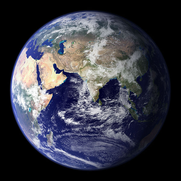
When I think about medieval mappaemundi, I often end up with an image in my mind of the planet earth seen from space, like this famous NASA photo. I think about how old the earth is, and yet how fragile and vulnerable it seems compared to the empty universe around it. I think about places and wonders from around the world, some of which I’ve seen, some of which I recognize from nature documentaries – the Serengeti, the Atlantic ocean, the Great Wall of China, Uluru. I think about all the human beings that have ever lived, all the history that has ever happened, all the ideas, philosophies, jokes, and music that have ever existed – all contained in this one photograph. Of course, a medieval mappamundi is very different from a NASA photo, but the way we react to one can help us understand the other.
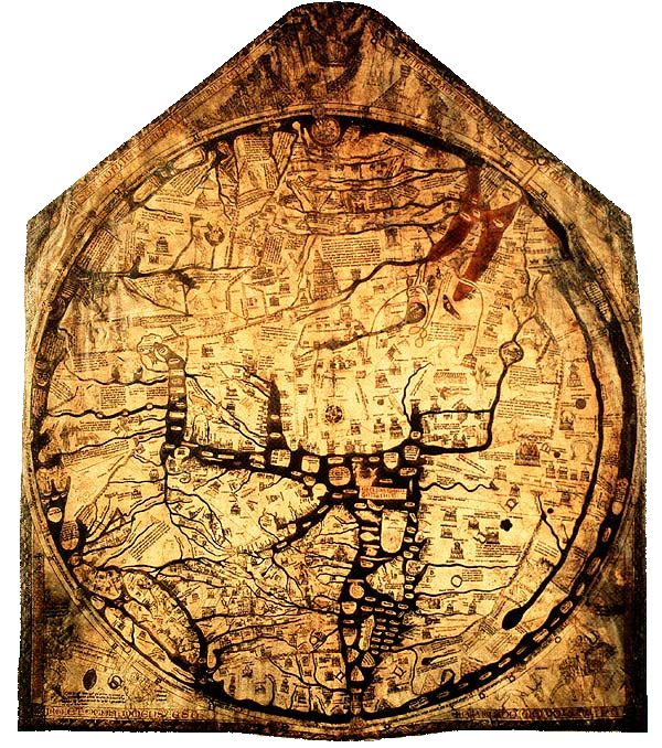
Mappaemundi (Latin for maps of the world) come in different forms – some divide the world into hot and cold zones, some are written texts rather than images – but for me, the most beautiful are the complex mappaemundi like the Hereford, Ebstorf, and Vercelli maps, produced in the thirteenth century. These are symbolic images of the world and are likely to have been used in a monastic context for devotional purposes.

Looking at a modern map, we expect places to be represented within a system of coordinates. So, for example, distances will be drawn to scale, and the size of a town will reflect its physical size, not its population, or its historical importance. Mappaemundi have a different aim, and different ways of representing space, so to approach them as ‘maps’ in a modern sense is a recipe for confusion.
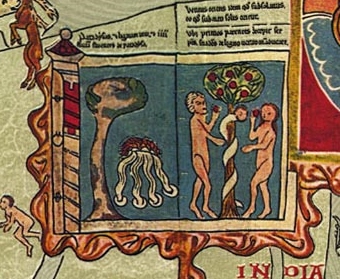
To start with, mappaemundi are usually oriented to the east, so the Garden of Eden at the extreme east of the world is at the very top of the image. Asia covers the top half (or thereabouts), Europe the bottom-left quarter and Africa the bottom-right. History, and biblical history in particular, is an important part of the maps’ content. A mappamundi is not a snapshot of a particular moment in time, but rather a rewriting of history onto world geography. Particular locations are shown in their moment of historical significance. In the Garden of Eden on the Ebstorf map, for example, the serpent can be shown tempting Adam and Eve with the forbidden fruit, while in Jerusalem, Christ is shown resurrected. The Vercelli map even has an image of Noah’s ark! Large chunks of text can also be included to explain the historical significance of a location.
A final important feature of mappaemundi are the so-called “monstrous races”. These include the Blemmyae (no heads and their eyes and mouths in their chests), the Sciapods (one-legged with one large foot, like the Dufflepuds in the Narnia books), and the Cynocephali (dog-headed people). You can see pictures of all of these in a brilliant 3D digitization of the Hereford map, here.
To the eyes of a medieval Christian, a mappamundi shows the whole of world history, from the creation of Adam and Eve up to the present day, as well as the entirety of the physical world, three continents bounded by sea. It also showed the variety of life on earth, represented by the Cynocephali, Blemmyae, and other monstrous races. Crucially for their makers, mappaemundi displayed all of this within a Christian framework. It is no accident that on the Ebstorf map, Christ’s head, outstretched arms and feet can be seen beyond the sphere of the world, embracing and encompassing the whole – even the monsters.
I cannot prove any final “meaning” of a mappamundi. I like to think, though, that a monk’s response to a mappamundi displayed in his monastery for contemplation might be similar to mine when confronted with NASA’s picture of the earth. The world as we know it is spread before us, beautiful, awful, infinitely varied, fragile, precious, and teeming with life. And that response, I think, is something worth sharing.

2 responses to “Medieval Mappaemundi (World Maps)”
[…] cartography fans like myself Julia Bourke takes a look at Medieval Mappaemundi. In my curiosity cabinet cartography and geology belong together and Sauropod Vertebra deliver some […]
Spot on with this write-up, I truly feel this amazing site needs a great deal more attention. I’ll probably be back again to read more, thanks for the information!